Understanding wind patterns is a crucial aspect of meteorology, aviation, and even outdoor activities like sailing or hiking. Weather maps often contain symbols that may look confusing at first glance—one of the most commonly used being wind barbs. These symbols provide quick and reliable information about both the direction and speed of the wind. For professionals and enthusiasts alike, learning how to interpret them is a fundamental skill that enhances situational awareness and decision-making.
What Are Wind Barbs?
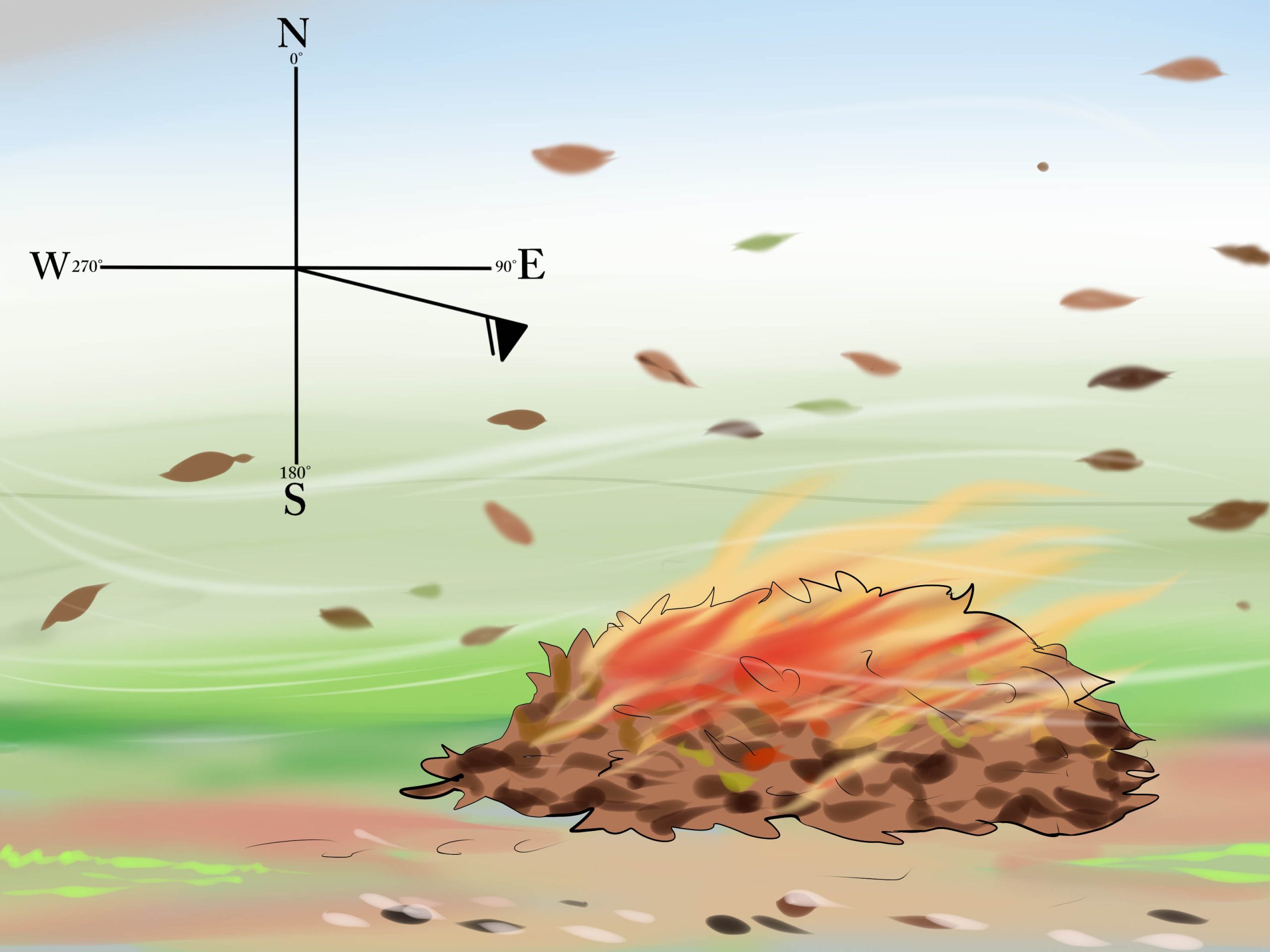
Wind barbs are graphic symbols used on weather maps to represent wind speed and direction at a specific location. They resemble arrows with lines or “feathers” extending from them, each indicating a certain wind velocity. The base of the barb represents the station’s location, the shaft shows the direction the wind is coming from, and the feathers indicate the wind’s strength.
Understanding these symbols allows meteorologists, pilots, and environmental analysts to quickly assess atmospheric conditions across regions. When viewed collectively, wind barbs offer a clear picture of how air masses are moving, which can help in forecasting weather patterns and identifying potential changes in pressure systems.
Learning How to Read Wind Barbs
If you’ve ever looked at a weather map and wondered what those little arrows mean, this guide will help you decode them step by step. The process of interpreting wind speed and direction can be easily mastered once you understand the basic principles. Here’s a complete explanation on how to read wind barbs and make sense of the data they represent.
Each wind barb includes three key pieces of information:
- The direction of the shaft: shows where the wind is coming from.
- The feathers or flags: represent wind speed.
- The location point: identifies where the measurement was taken.
For example, if the shaft points toward the southeast, it means the wind is blowing from the southeast toward the northwest.
Understanding Wind Speed Symbols
Wind barbs use a system of small lines or shapes to indicate wind velocity. The number and type of these lines determine how strong the wind is:
- Short barb: represents 5 knots.
- Long barb: represents 10 knots.
- Triangle (flag): represents 50 knots.
To calculate the total wind speed, you simply add up the values represented by the symbols. For instance:
- A long barb and a short barb together represent 15 knots.
- A flag and two long barbs would represent 70 knots (50 + 10 + 10).
If there are no barbs at all, it usually indicates calm winds, typically less than 2 knots.
Decoding Wind Direction
The direction of the wind is shown by the orientation of the shaft or arrow. The tail of the wind barb points toward the direction the wind is coming from. So, if the barb points downward on a map (toward the south), it means the wind is blowing from the north toward the south.
It’s important to remember that meteorologists describe wind based on its origin—not its destination. A “northerly wind” means air is coming from the north, not blowing toward it.
This method helps standardize communication and ensures consistent reporting across different regions and weather networks.
Common Examples and Interpretations
To get comfortable reading wind barbs, let’s look at a few practical examples:
- Example 1: A wind barb with one long line and one short line pointing east indicates a wind coming from the east at 15 knots.
- Example 2: A barb with a triangle and two long lines pointing north suggests strong winds from the north at 70 knots.
- Example 3: A circle with no barbs means calm wind conditions, often found during high-pressure systems or early morning hours.
By studying multiple barbs on a map, you can quickly identify regions of high or low wind activity, detect weather fronts, and anticipate shifts in temperature or pressure.
Why Wind Barbs Are Important
Wind barbs play a vital role in several fields where understanding wind behavior is critical:
1. Aviation
Pilots rely heavily on accurate wind data for safe takeoff, flight, and landing operations. Wind barbs displayed on aviation weather charts help them determine headwinds, tailwinds, and crosswinds, which affect aircraft performance and fuel efficiency.
2. Marine Navigation
Sailors and maritime professionals use wind barb information to plan routes, adjust sails, and avoid hazardous weather. Knowing wind speed and direction helps ensure safer voyages and efficient navigation.
3. Meteorological Forecasting
Meteorologists use wind barbs to analyze pressure gradients and identify weather systems such as storms or cyclones. A cluster of high-speed winds can signal the presence of a cold front or tropical disturbance.
4. Renewable Energy Planning
Wind energy engineers use wind barb data to evaluate potential sites for turbines, ensuring they’re positioned to capture maximum wind energy throughout the year.
5. Outdoor and Environmental Monitoring
For hikers, researchers, and environmentalists, wind barbs provide valuable insight into local weather conditions, enabling safer and more informed decision-making.
Reading Wind Barbs on Different Maps
Wind barbs are found on various types of meteorological charts, each providing unique insights:
- Surface Weather Maps: Show wind conditions at ground level, useful for predicting local weather and identifying fronts.
- Upper Air Charts: Represent winds at different atmospheric levels, helping forecast jet streams and air mass movements.
- Station Models: Include wind barbs along with temperature, pressure, and humidity data, giving a complete snapshot of weather conditions at specific observation points.
When combined with temperature gradients and pressure contours, wind barbs can help forecast short-term weather changes more effectively than text-based data alone.
Tips for Accurate Interpretation
To make sure you read wind barbs correctly, keep these tips in mind:
- Always check map orientation: Ensure north is at the top of the chart to avoid confusion about direction.
- Look for patterns, not just individual points: Wind direction often changes gradually, indicating shifts in weather fronts.
- Combine with other data: Cross-reference wind information with temperature and pressure readings for a complete understanding.
- Use consistent units: Wind speed may be given in knots, mph, or km/h—make sure you’re interpreting the correct scale.
The Evolution of Wind Data Representation
While traditional wind barbs remain a standard in meteorology, technology is enhancing how we visualize wind information. Modern digital systems and meteorological software can overlay wind barbs on satellite images or use animated flow vectors to depict real-time motion.
These visualizations make it easier for both experts and the public to grasp complex atmospheric behaviors. However, the simplicity and precision of wind barbs continue to make them a universal standard across weather maps and aviation charts worldwide.
Final Thoughts
Learning to read wind barbs is an essential skill for anyone interested in understanding weather data. Although they may seem complicated at first, their logical structure makes them one of the most efficient ways to represent wind conditions visually.
By recognizing how the direction, speed, and symbols interact, you gain the ability to interpret atmospheric movements with confidence. Whether you’re a meteorologist, pilot, sailor, or simply a weather enthusiast, mastering wind barbs enhances your understanding of the natural forces shaping our skies—and ultimately, our daily lives.
George is the voice behind Wisdomised, a news blog dedicated to delivering fresh, engaging stories that keep readers both informed and entertained. With a sharp eye for current events and trending topics, George crafts posts that make complex news accessible and enjoyable. His unique perspective and storytelling skills bring a refreshing twist to every update, inviting readers to explore the world through Wisdomised.